 Rita is currently rated as a category 5 although when it hits land it is expected to go down to atleast a category 3...still bad and is currently heading towards Galveston. I hope people are careful driving out of town and not panicky drivers.
Wind in Houston, Friday night, are forcasted to be high of 70MPH with gusts of 80 to 100MPH...not good for flying objects and windows. Take precautions.
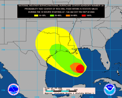
Strike Probabilities
The image shows the probability, in percent, that the center of the tropical cyclone will pass within 75 statute miles of a location during the 72 hours beginning at the time indicated in the caption. The caption also provides the name of the tropical cyclone and the advisory number from which the probabilities were generated. Contour levels shown are 10%, 20%, 50% and 100%.
++ Click here for NOA updates for Houston and Galveston
++ Also, for a visible loop (video) of Rita's path click here. click on the last box to get the forcast points.
++ another good site for maps and info

1 comment:
here is another link: http://www.wunderground.com/tropical/tracking/at200518.html
I'm really worried about the current storm track. Looks bad for Both Houston and N.O.
Hope everyone is keeping safe.
Post a Comment